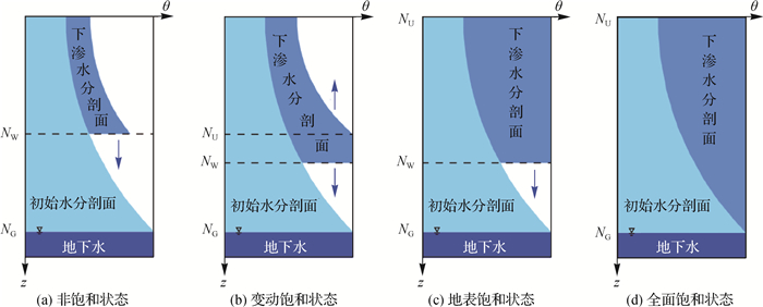
A runoff generation and concentration model based on the variable saturation zone concept and its parameter determination
-
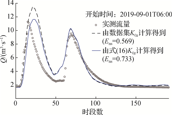
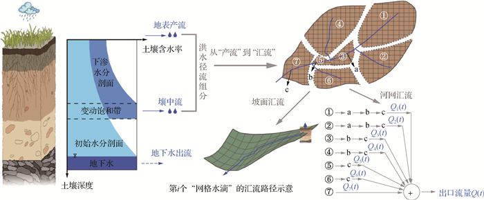
摘要: 当前分布式水文模型的参数确定仍主要依赖率定方式, 在缺资料地区应用受到限制。建立一种基于变动饱和带产流模式和网格水滴汇流方法的分布式产汇流模型, 提出利用下垫面特征来确定模型参数的方法。结合野外入渗试验和参数敏感性分析, 建立地表饱和水力传导度(K0z)和饱和水力传导度随深度衰减系数(f)2个敏感性产流参数与地形参数、土壤类型数据的定量统计关系, 利用野外坡面流观测试验确定坡面汇流参数, 并在多个实际流域进行应用验证。结果表明: ①利用地形参数确定K0z与使用遥感资料确定K0z的模型精度进行对比, 在姜湾实验流域场次洪水模拟的平均确定性系数从0.82提高至0.86, 洪峰与洪量误差的平均绝对值分别降低了2.2%和0.95%, 但峰现时间误差平均绝对值增大了4%(仍控制在2 h内)。②建立姜湾等14个流域参数f率定值与不同深度土壤类型数据的定量关系, 移用至七邻等6个流域进行验证, 表明参数f关系式与模型率定的精度非常接近, 相对误差的平均绝对值为2.8%, 场次洪水模拟的平均确定性系数为0.83, 洪峰与洪量误差的平均绝对值为10.07%和6.86%, 峰现时间误差的平均绝对值为2.61 h。提出的敏感性产流参数确定方法与野外实测、模型率定、遥感资料推求等方式进行对比, 均具有较高的参数估计精度和场次洪水模拟精度, 在缺资料地区具有适用性。Abstract: The calibration processes of current distributed hydrological model has been a critical issue in data-scared or ungauged regions. In this study, we setup a hydrological model, in which, the variable saturated zone concept originated from the real-time interactive basin simulator is applied for runoff generation and the grid water droplet method for flow concentration. We also proposed a method for parameter estimation based on the characteristics of underlying surface. Based on field infiltration experiments and parameter sensitivity analysis, the quantitative statistical relationships were built between two sensitive parameters (surface saturated hydraulic conductivity K0z, coefficient of attenuation of saturation hydraulic conductivity with depth f) and the topographic parameters and soil types. The overland confluence parameters were determined by field overland flow observation experiments. The proposed parameter estimation method was verified in selected basins. Our results showed that: ① The proposed method for K0z estimation contributes to a better modeling performance for flood simulation in Jiangwan experimental watershed, the average Nash-Sutcliffe efficiency coefficient increased from 0.82 to 0.86, and the average absolute values of peak and flood volume errors decreased by 2.2% and 0.95%, respectively, but the average absolute value of the peak present time error increased by 4% (still controlled within 2 h). ② Using the measured flood data of 14 basins such as Jiangwan to calibrate the parameter f, we established the quantitative relationship between the calibrated parameter f and the soil type data of different depths was built in 14 basins including Jiangwan, and further tested in other six basins. The parameter f estimated by the soil type data of different depths was very close to that determined by traditional model calibration processes, the average absolute relative error is 2.8%, the average Nash-Sutcliffe efficiency coefficient of the flood simulation is 0.83, and the average absolute values of flood peak error and flood volume error were 10.07% and 6.86%, respectively, and the average absolute peak present time error was 2.61 h. Our results indicated that the proposed methods for determining sensitive runoff generation parameters are applicable in data-sparse areas and could provide a better or comparable parameter estimation and flood simulation than that determine by field measurements, model calibration, remote sensing data estimation, and other methods.
-
-
表 1 选用的20个流域地理位置和控制面积
Table 1 Locations and control areas of 20 selected basins
序号 流域 水文站 出口断面位置 控制面积/km2 气候条件 1 梅家塘 太湖姜湾实验流域梅家塘断面 30°35′52″N,119°46′56″E 5.6 湿润 2 范坞里 太湖姜湾实验流域范坞里断面 30°34′34″N,119°48′47″E 14.8 湿润 3 古竹湾 太湖姜湾实验流域古竹湾断面 30°34′57″N,119°47′53″E 10.4 湿润 4 佛堂村 太湖姜湾实验流域佛堂村断面 30°34′38″N,119°49′10″E 17.1 湿润 5 北庙集 淮河北庙集站 32°16′58″N,115°25′34″E 1 701 湿润 6 潢川 淮河潢河潢川站 32°09′35″N,115°05′06″E 2 060 湿润 7 秦渡镇 渭河秦渡镇站 34°08′23″N,108°45′01″E 1 029 半湿润 8 千阳 渭河千阳站 34°37′58″N,107°08′20″E 2 933 半湿润 9 甘谷 渭河甘谷站 34°39′06″N,105°20′26″E 2 480 半干旱 10 清涧河 清涧河延川站 36°53′09″N,110°11′16″E 3 468 半干旱 11 香屯 乐安河香屯站 29°02′18″N,117°37′04″E 3 341 湿润 12 三台 嘉陵江三台站 31°02′15″N,105°01′23″E 2 227 湿润 13 平武 嘉陵江平武站 32°25′43″N,104°31′19″E 4 284 半湿润 14 甘溪 嘉陵江甘溪站 31°56′41″N,104°40′03″E 1 065 半湿润 15 七邻 淮河史河七邻站 31°26′33″N,115°44′40″E 91 湿润 16 黄泥庄 淮河史河黄泥庄站 31°27′19″N,115°36′47″E 787 湿润 17 长台关 淮河长台关站 32°18′21″N,114°03′30″E 3 029 湿润 18 三都 乐安河三都站 29°17′00″N,117°50′54″E 1 392 湿润 19 东湾 黄河伊河东湾站 34°03′24″N,111°58′35″E 2 647 半湿润 20 汝州 淮河沙颍河汝州站 34°08′06″N,112°50′42″E 2 803 半湿润 表 2 参数K0z确定方法在姜湾流域场次洪水模拟中验证结果
Table 2 Validation of the estimation method of parameter K0z in Jiangwan experimental watershed
流域 数据集K0z值 式(16)K0z值 Ens |Epeak|% |ΔTpeak|/h |Evol|/% Ens |Epeak|/% |ΔTpeak|/h |Evol|/% 梅家塘 0.80 13.67 1.31 6.81 0.85 10.41 1.50 6.54 古竹湾 0.80 10.73 1.75 5.35 0.83 10.06 1.66 3.34 范坞里 0.84 11.06 1.75 6.55 0.87 8.03 1.94 6.38 佛堂村 0.84 10.69 1.97 6.44 0.87 8.86 2.00 5.09 平均 0.82 11.54 1.70 6.29 0.86 9.34 1.77 5.34 注: |·|表示所有场次洪水模拟结果精度指标绝对值的平均值。 表 3 参数f确定方法在6个流域场次洪水模拟中验证结果
Table 3 Validation of the estimation method of parameter f in six basins
流域 模型率定f值 式(17)f值 Ens |Epeak|% |ΔTpeak|/h |Evol|/% Ens |Epeak|% |ΔTpeak|/h |Evol|/% 七邻(2001—2010年10场次洪) 0.82 8.81 1.50 5.05 0.81 11.80 1.50 7.83 黄泥庄(2002—2010年11场次洪) 0.84 12.17 2.36 5.41 0.83 11.80 2.82 6.35 长台关(2000—2010年10场次洪) 0.86 5.76 3.40 7.50 0.86 5.65 3.40 8.45 三都(2011—2018年12场次洪) 0.84 13.58 2.25 5.59 0.83 13.52 2.42 6.03 东湾(1965—1998年10场次洪) 0.84 9.23 2.20 5.91 0.84 9.54 2.30 6.12 汝州(2000—2010年9场次洪) 0.82 8.91 3.11 5.64 0.80 8.13 3.22 6.40 平均 0.84 9.74 2.47 5.85 0.83 10.07 2.61 6.86 注: |·|表示所有场次洪水模拟结果精度指标绝对值的平均值。 -
[1] 王浩, 严登华, 贾仰文, 等. 现代水文水资源学科体系及研究前沿和热点问题[J]. 水科学进展, 2010, 21(4): 479-489. http://skxjz.nhri.cn/article/id/240 WANG H, YAN D H, JIA Y W, et al. Subject system of modern hydrology and water resources and research frontiers and hot issues[J]. Advances in Water Science, 2010, 21(4): 479-489. (in Chinese) http://skxjz.nhri.cn/article/id/240
[2] 雷晓辉, 王浩, 廖卫红, 等. 变化环境下气象水文预报研究进展[J]. 水利学报, 2018, 49(1): 9-18. https://www.cnki.com.cn/Article/CJFDTOTAL-SLXB201801003.htm LEI X H, WANG H, LIAO W H, et al. Advances in hydro-meteorological forecast under changing environment[J]. Journal of Hydraulic Engineering, 2018, 49(1): 9-18. (in Chinese) https://www.cnki.com.cn/Article/CJFDTOTAL-SLXB201801003.htm
[3] LI D Y, LIANG Z M, ZHOU Y, et al. Multicriteria assessment framework of flood events simulated with vertically mixed runoff model in semiarid catchments in the Middle Yellow River[J]. Natural Hazards and Earth System Sciences, 2019, 19(9): 2027-2037. doi: 10.5194/nhess-19-2027-2019
[4] 张建云, 王国庆, 金君良, 等. 1956—2018年中国江河径流演变及其变化特征[J]. 水科学进展, 2020, 31(2): 153-161. doi: 10.14042/j.cnki.32.1309.2020.02.001 ZHANG J Y, WANG G Q, JIN J L, et al. Evolution and variation characteristics of the recorded runoff for the major rivers in China during 1956—2018[J]. Advances in Water Science, 2020, 31(2): 153-161. (in Chinese) doi: 10.14042/j.cnki.32.1309.2020.02.001
[5] 王怀军, 张建云, 王国庆, 等. 中国中小河流气候和下垫面与产汇流过程关系研究[J]. 地理科学, 2021, 41(1): 109-120. https://www.cnki.com.cn/Article/CJFDTOTAL-DLKX202101012.htm WANG H J, ZHANG J Y, WANG G Q, et al. Relationships between climate, underlying surface and runoff yield and flow concentration processes in China's middle and small rivers[J]. Scientia Geographica Sinica, 2021, 41(1): 109-120. (in Chinese) https://www.cnki.com.cn/Article/CJFDTOTAL-DLKX202101012.htm
[6] LI D Y, LIANG Z M, LI B Q, et al. Multi-objective calibration of MIKE SHE with SMAP soil moisture datasets[J]. Hydrology Research, 2019, 50(2): 644-654. doi: 10.2166/nh.2018.110
[7] GARROTE L, BRAS R L. A distributed model for real-time flood forecasting using digital elevation models[J]. Journal of Hydrology, 1995, 167(1/2/3/4): 279-306.
[8] CABRAL M C, GARROTE L, BRAS R L, et al. A kinematic model of infiltration and runoff generation in layered and sloped soils[J]. Advances in Water Resources, 1992, 15(5): 311-324. doi: 10.1016/0309-1708(92)90017-V
[9] IVANOV V Y, VIVONI E R, BRAS R L, et al. Catchment hydrologic response with a fully distributed triangulated irregular network model[J]. Water Resources Research, 2004, 40(11): W11102.
[10] 李红霞, 张新华, 张永强, 等. 缺资料流域水文模型参数区域化研究进展[J]. 水文, 2011, 31(3): 13-17. LI H X, ZHANG X H, ZHANG Y Q, et al. Review of hydrological model parameter regionalization for ungauged catchments[J]. Journal of China Hydrology, 2011, 31(3): 13-17. (in Chinese)
[11] 刘金涛, 宋慧卿, 王爱花. 水文相似概念与理论发展探析[J]. 水科学进展, 2014, 25(2): 288-296. http://skxjz.nhri.cn/article/id/2405 LIU J T, SONG H Q, WANG A H. Advances in the theories of hydrologic similarity: a discussion[J]. Advances in Water Science, 2014, 25(2): 288-296. (in Chinese) http://skxjz.nhri.cn/article/id/2405
[12] 芮孝芳. 单元嵌套网格产汇流理论[J]. 水利水电科技进展, 2017, 37(2): 1-6. https://www.cnki.com.cn/Article/CJFDTOTAL-SLSD201702001.htm RUI X F. Theory of runoff yield and confluence by grid inlaid in watershed basic unit[J]. Advances in Science and Technology of Water Resources, 2017, 37(2): 1-6. (in Chinese) https://www.cnki.com.cn/Article/CJFDTOTAL-SLSD201702001.htm
[13] BEVEN K. Infiltration into a class of vertically non-uniform soils[J]. Hydrological Sciences Journal, 1984, 29(4): 425-434. doi: 10.1080/02626668409490960
[14] BROOKS R H, COREY A T. Hydraulic properties of porous media[J]. Hydrology Paper, 1964, 7: 26-28.
[15] 刘金涛, 冯德锃, 陈喜, 等. 山坡地形曲率分布特征及其水文效应分析: 真实流域的野外实验及相关分析研究[J]. 水科学进展, 2011, 22(1): 1-6. http://skxjz.nhri.cn/article/id/1773 LIU J T, FENG D Z, CHEN X, et al. Distribution charateristics of hillslope curvature and its effects on hydological processes: a real-world test[J]. Advances in Water Science, 2011, 22(1): 1-6. (in Chinese) http://skxjz.nhri.cn/article/id/1773
[16] BEVEN K, BINLEY A. The future of distributed models: model calibration and uncertainty prediction[J]. Hydrological Processes, 1992, 6(3): 279-298. doi: 10.1002/hyp.3360060305
[17] DAI Y J, SHANGGUAN W, DUAN Q Y, et al. Development of a China dataset of soil hydraulic parameters using pedotransfer functions for land surface modeling[J]. Journal of Hydrometeorology, 2013, 14(3): 869-887. doi: 10.1175/JHM-D-12-0149.1
[18] VIEUX B E. Distributed hydrologic modeling using GIS[M]//Water Science and Technology Library. Dordrecht: Springer Netherlands, 2001: 1-17.
[19] ZHAO C S, ZHANG C B, YANG S T, et al. Calculating e-flow using UAV and ground monitoring[J]. Journal of Hydrology, 2017, 552: 351-365. doi: 10.1016/j.jhydrol.2017.06.047
[20] 姚蕾. 缺资料地区产汇流模型研究[D]. 南京: 河海大学, 2014. YAO L. Research of runoff model in ungauged basins[D]. Nanjing: Hohai University, 2014. (in Chinese)
-
期刊类型引用(4)
1. 邓晰元,郑锦涛,周晓辉,马涛,郑皓,梁秀,王国庆. 基于PCA-HCA模型的我国节水分区. 南水北调与水利科技(中英文). 2023(01): 137-147 .  百度学术
百度学术
2. 王紫荆,徐梦珍,胡宏昌,张向萍. 1982—2020年黄河流域植被变化特征及驱动因素. 水科学进展. 2023(04): 499-509 .  本站查看
本站查看
3. 翟家齐,赵勇,刘宽,董义阳,李星. 干旱区灌溉绿洲农业节水潜力形成机制与评估方法. 水利学报. 2023(12): 1440-1451 .  百度学术
百度学术
4. 杨翊辰,刘柏君. 黄河流域典型灌区节水潜力评估. 海河水利. 2021(03): 10-15 .  百度学术
百度学术
其他类型引用(4)


 下载:
下载:
